Saline River Fishing Spot
- Elevation: 341'
- Last Modified By: vinny60 on 09/14/09 09:47 AM
- Ask about Saline River in our Fishing Forums
Photos
Fish Species
Saline River Description
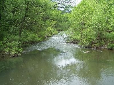
The Saline River maintains the intangible quality of timelessness. Born of the rivulets that flow out of the eastern foothills of the rugged Ouachita Mountains, its three major divisions--Middle, Alum and North Forks--merge above Benton. Below this point the river flattens out to begin its long journey through Grant, Cleveland, Bradley and Ashley counties to its confluence with the Ouachita River in the heart of Felsenthal National Wildlife Refuge. The Saline River is the last major undammed stream in the entire Ouachita Mountain drainage, and its watershed contains some of the finest deer, turkey and squirrel hunting in Arkansas. That, combined with the excellent fishing, scenery and backcountry floating that the river produces, makes it no wonder that Arkansans who know it regard the river with an almost fanatical devotion. The upper portion of the Saline, above Benton, is characterized as a clear, cold-water section with a series of fast-running shoals interspersed with short, quiet pools. The middle section of the river (Benton to Warren) contains long pools and few riffles with clear to murky water. The river's lower section below Warren has sluggish current with slightly murky water. The Saline is one of only a few rivers that has a gravel bottom throughout its entire length. Access to the Saline is generally at state highway crossings, county road crossings and numerous little-known fords and ferry sites. The Arkansas Game and Fish Commission has developed several access points along the river, including (working downstream): a boat ramp off Highway 229 on a forest road between Traskwood and Poyen; Lee's Ferry Access from Highway 35; Pool access at Highway 79; Mt. Elba off Highway 35; Highway 4 out of Warren; at Longview off Highway 189 between Fountain Hill and Johnsville; and Stillions at the mouth of the canal right below Lake Georgia Pacific. There is also access in Grant County at Jenkins' Ferry Historical Monument between Sheridan and Leola. The Saline is one of the most underrated fishing rivers in Arkansas. Smallmouth bass abound in the upper reaches; largemouth bass occupy the lower reaches; and the intermediate water between has a healthy population of spotted bass that overlaps into both areas. The warmouth, longear, and green sunfish top the panfish offering, with some bluegills and crappie. The river also has a good walleye fishery, and channel catfish are common. Rock bass are found in association with smallmouth bass on the upper third of the river. Fishing during much of the year is a "wade a little, fish a little" proposition, and for this reason, canoes are much preferred over the traditional flatbottom johnboat. A motor is normally more trouble than it's worth on headwater float trips, though a light electric trolling motor can be a real boon at times. The Saline remains relatively unspoiled by man and creates an illusion of wilderness along much of its length. Dense forests line the river banks. Visitors may be treated to the sight of deer, mink, otters, beaver, muskrats and a variety of bird species.
Saline River may refer to several rivers: