Little Red River Fishing Spot
- Elevation: 461'
- Last Modified By: vinny60 on 09/14/09 10:48 AM
- Ask about Little Red River in our Fishing Forums
Photos
Fish Species
Comments
-
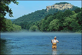
The secret to fishing the Little Red is light tackle and small lures. Ultralight spinning rigs and two- to four-pound line are popular. Most trout are taken on bait, rather than artificial simply because more anglers use it. Whole kernel corn, redworms, nightcrawlers, waxworms, salmon eggs, and Velveeta cheese all take their share. Favorite artificials for Little Red trout include marabou jigs, small spinners and spoons, and crayfish- and minnow-imitation crank-baits. But one of the most productive techniques involves a curious marriage between bait and artificial This rig consists of a small, clear bobber rigged about four or five feet above a brown feather jig, on the barb of which is impaled a small white waxworm. The rig is cumbersome to cast, but that's acceptable since the proper fishing technique is to work the lure in as slowly as possible. During highwater, driftfishing with the current is favored. Bait is cast upstream and allowed to bump the bottom as it drags behind the boat. On low water, stillfishing deep holes, weedbeds, and timber from an anchored boat is preferred. The Little Red is also one of Arkansas's most popular flyfishing streams, and the many shoals exposed during low water periods offer ideal locations to hook a hefty trout on a variety of fly patterns. Arkansas's trout season never closes, but many of the larger fish are taken from October through February.
Little Red River Description
The Little Red River is a river in north-central Arkansas.The upper tributaries of the Little Red River are known as the South Fork, the Middle Fork, and the Devils Fork. The South Fork begins in the Ozark National Forest near Scotland in Van Buren County and flows into Greers Ferry Lake near Clinton. The Middle Fork begins only a few miles from the South Fork near Tilly in Van Buren County but flows northward into Searcy County. In Searcy County the river turns east and flows into Stone County where it turns south and flows to meet Greers Ferry Lake in Cleburne County. The Devils Fork begins in Northeastern Cleburne County, Arkansas and flows southwest to meet Greers Ferry Lake near Ida, Arkansas. The three forks converge into the North section of Greers Ferry Lake, which is connected to the South section of the lake by the Narrows, the site of the former Little Red River. The Little Red River begins to flow again at the Army Corps of Engineers hydroelectric dam at Heber Springs. Little Red River, emerging icy cold from beneath massive dam at Greers Ferry Lake is a premier-class trout stream. Trout were introduced to the Little Red in 1966, some three years after the completion of the lake project. Rainbows, browns and cutthroats are caught for some 35-river miles below the dam. Howard "Rip" Collins caught a 40-pound, four-ounce world record brown on the river in 1992...a mark that still stands. Full service marinas and resorts are available along the upper sections of the Little Red. Both public and resort launch areas are conveniently located on both sides of the river. Attractions in the area include the William Carl Garner/Corps of Engineers Visitor Center, hiking trails overlooking the river, trout hatchery; plus boating, fishing, and resort villages around the lake. The first few miles of river below Greers Ferry Lake are strewn with boulders, making a challenging float for canners, but a difficult one for crafts larger than a johnboat. Beyond this stretch, there is a long pool of deep water. Farther downstream, an island hinders river travel. The usual approach is to veer left at the island, which will take floaters into one of the river's largest fishing holes. Approximately one and one-half miles downstream, a series of shoals impedes travel of large boats when water levels are low. Beyond this shoal area, canoes are the best choice for shallow areas and a series of bends. Next is a three-mile-long deep hole, followed by a narrowing of the river into another long shoal. These shoals give way to deep pools above Pangburn, then the river's pace picks up with a series of rapids upstream of the low water bridge north of town. Beyond the rapids, the river widens as it flows through another series of shoals. The last access point, Ramsey Access, is a few miles downstream. Total distance from the dam to the last access is 29 miles. Trout waters end a few miles beyond the Ramsey area at Arkansas 305. Water conditions on the Little Red don't vary so much by season as they do by day of the week. On weekdays, when power demand is usually at its greatest, water is frequently released around mid-morning. Demand for elec- tricity drops over the weekends, and so do water levels. When the river reading is low, expect to wade and drag boats over the shoals. The Little Red is among the real blue-ribbon trout streams of America and takes her place alongside the White as one of the best in the South. Hundreds of thousands of rainbow trout are stocked here annually, and periodic releases of brown trout have produced an excellent fishery for that species as well.
The Little Red River is a river in north-central Arkansas. During the American Civil War the Battle of Whitney's Lane took place near Searcy on the banks of the Little Red.